As advancements in hardware and software technology continue to lead the charge of digital transformation, various traditional industries will be required to shift their strategies – construction being one of them. Connected Construction is defined by Deloitte as a “dynamic ‘always on’ network providing continuous flow of information and analytics.” In this connected construction ecosystem, stakeholders – from onsite managers to in-office designers – are able to seamlessly integrate their workflows, have real-time project visibility, and transparently track assets for respective tasks. This is especially important in construction, given the safety critical factors and risks associated with the field of work.
The integration of workflows in a construction environment is especially important because of the permanence of decisions once they are made. There is a direct correlation between the amount of construction spending and infrastructural damage done, specifically to utility and telecommunications infrastructure, during excavation. According to the 2021 Damage Information Reporting Tool (DIRT) report, there were over “230,000 reports on [infrastructural] damages and near misses” during excavation projects in the United States and Canada.
Infrastructure damage of this kind is often due to miscommunication between stakeholders that may or may not be at the site, and inconsistencies in their respective documentation regarding the project at hand. Integrated workflows and collaboration mitigate this problem by leveraging cloud technology to make every facet of a construction project transparent to all stakeholders, and available in a centralized repository, thus influencing real-time decisions made at the site. In the same vein, other onsite construction risks such as work-related injury and death are mitigated by the integration of workflows and collaboration. Collaborating in this manner allows the relevant parties to make decisions with confidence, and thus move faster and more efficiently without causing infrastructure damage and mitigating other risks.
SiteMap’s innovative platform promotes connected construction in two major ways: 1. Real-time project visibility and 2. Collaboration on as-built drawings. Real-time project visibility entails the ability to view surface level obstructions as well as subsurface obstructions on a construction site. By leveraging 3D mapping & modeling data and cloud technology, stakeholders can render digital visualizations of a site that match real-time information from aerial drone imagery, onsite 3D laser scanning & imaging, and underground inspection imagery. Real-time project visibility also enables the monitoring of construction build progress by adding context to as-built drawings. As-built drawings are typically made by the project architect and are responsible for initial surveying of the site, exact dimensions of the space, location of obstructions and change orders made to reflect live inspections. Over the lifetime of a job site and as general contractors change over time, there is no objective archive of as-built drawings and significant details can become lost. This lack of accuracy in documentation can result in current as-built drawings not accounting for unforeseen obstructions – compromises the safety of the workers on site – and prolongs project timelines. Real-time project visibility streamlines the process by creating an objective repository of past as-built drawings, and visualizes what the site looks like throughout the process to prevent this from happening.
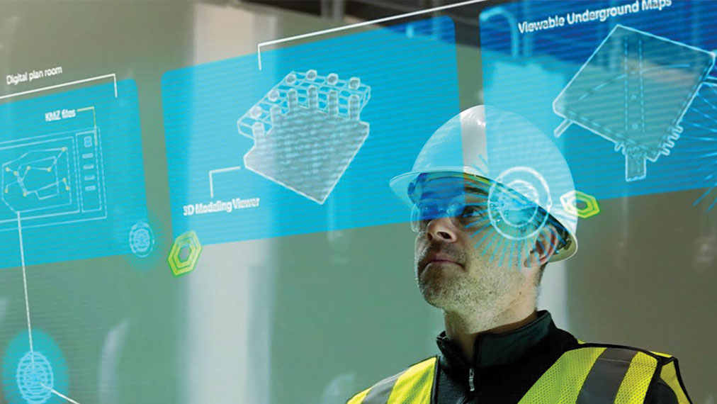
With SiteMap®, powered by GPRS, customers are able to meet the connected construction objectives of workflow integration and real-time visibility. Within the SiteMap® platform are two innovative enablers of connected construction: Digital Plan Room and Map Viewer.
Digital Plan Room:
The Digital Plan Room is a cloud-based data storage solution and repository in which users can view, upload, edit, and create a historical record of pre-existing as-built drawings and GPRS – generated data.
Traditional methodology, aka the status quo, is that site information is distributed and not accessible to all parties involved: causing general contractors to look in multiple databases for critical information like underground obstruction data from utilities, and up-to-date aerial imagery. This discrepancy in information allows for pivotal site decisions to be made without holistic knowledge of the area, and thus causes the overall team to go over budget, lose time, and misallocate resources.
SiteMap’s Digital Plan Room is strategically aligned to prevent these inefficiencies. By allowing all stakeholders in a construction project to have a collaborative and centralized view of mission-critical documents, the Digital Plan Room enables construction teams to:
- Breakdown silos and transparently communicate towards common goals on projects
- Edit and append auxiliary information to their databases
- Drive their projects forward with full confidence that their data is objectively correct
Map Viewer:
SiteMap’s Map Viewer is an enabler of real-time visibility for clients that use SiteMap®. It enables users to collaborate on, view and edit GIS data, as well as perform walkthroughs of sites via 3D based augmented reality.
With SiteMap®, users are able to interact with digital twins of their physical sites. This includes existing aerial imagery taken from drones, concrete scanning, underground utility, leak detection, and pipe inspection data, point cloud data from 3D laser scans, the location of subsurface infrastructure such as storage tanks, concrete slabs, and more.
The Map Viewer can leverage GPRS’ state-of-the art technology in location and mapping infrastructure. SiteMap employs a fusion of methodologies to identify and gather data on the subterranean utilities of a job site. These methods include:
- Ground Penetrating Radar for detecting subterranean objects of metallic and non-metallic structure
- Electromagnetic Locating for identifying and mapping underground utilities
- Static Cameras and Robotic Camera Crawlers systems for pipeline and sewer inspection
- Acoustic Devices for non-invasively detecting pipe leaks and discrepancies
By combining the strengths of integrating workflows via Digital Plan Room and providing real time project visibility via Map Viewer, SiteMap® is uniquely positioned to disrupt the connected construction industry. By integrating SiteMap® into their existing businesses, users will be able to streamline projects and deliver better solutions to their customers.
SiteMap® products and services are designed to streamline your project processes and save you money. To learn more about what SiteMap® offers, download our brochure and contact us for a quote today!