The Top Three Utility Locating Errors and How to Avoid Them
The Common Ground Alliance (CGA) and their Data Reporting & Evaluation Committee have issued their latest comprehensive account and analysis “of damages to buried infrastructure in the U.S. and Canada” through their Damage Information Reporting Tool (DIRT) Report.
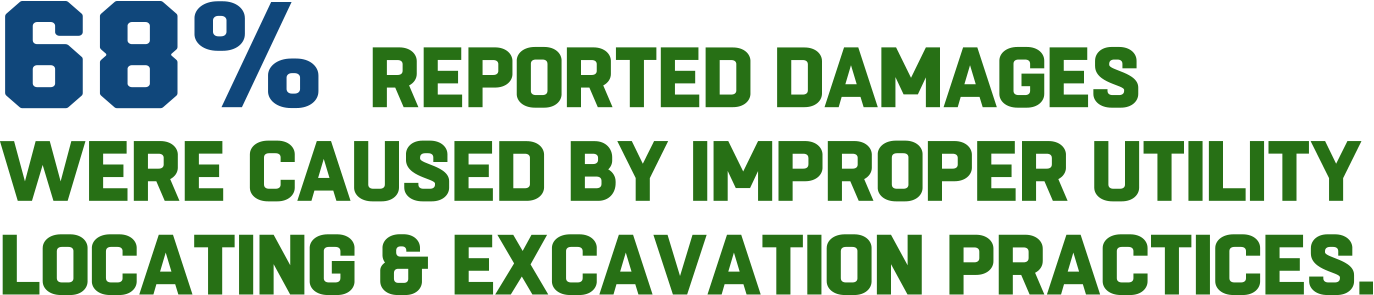
Within this report they provided a full Root Cause Analysis, which uncovered that the overwhelming majority of construction damages were reportedly caused by improper utility locating and excavation practices, which represent a combined 68% of reported damages. Furthermore, after taking a closer look at the exact locating errors that have caused such a large amount of damages, the top three were reported at 66% was due to locator error, 12% from incorrect maps and records, and 11% due to incorrect or incomplete evaluation markings.
Utility locating is a crucial evaluation to ensure the success of any project and should not be overlooked. By collecting accurate data for all buried utilities, their exact locations, and how they spatially relate to each other, facility managers can properly plan out their project timeline and safety measures. This process also helps to protect site employees from potential line strike damage, and avoids unnecessary cost overruns, change orders, and/or redesigns. Lastly, maintaining detailed, up-to-date, accurate facility maps and models of all underground utilities located on the job site is key to sustaining proper communication on any construction project.
GPRS’ state-of-the-art Utility Locating Services and the virtual filing and visualization software at SiteMap®, provide our customers with solutions to all of the “top three” issues assessed in the DIRT Report.
Our Problem: Locator Errors
Solution: GPRS’s Modern Utility Locating Service Tools
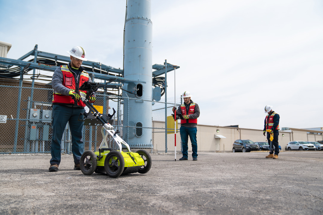
Our GPRS utility locating services utilize modern, non-destructive scanning & imaging tools to evaluate the subsurface of any given site for utilities. These fully comprehensive services help you to avoid unexpected, costly surprises before your project breaks ground. These modern utility locating tools and services include…
- Ground Penetrating Radar (GPR): GPR is a method of utility detection which relies on radio waves to accurately identify any subsurface components which are hidden or buried. GPRS has maintained a consistent 99.8% accuracy rate in concrete imaging.
- Electromagnetic (EM) Locating: Electromagnetic pipe and cable locators use a rodder or sonde to emit a specific frequency which the receiver then detects to precisely locate the underground utility.
- Sondes: These utility locating probes allow our Project Managers to identify the location of underground utilities from an inaccessible location.
- Electromagnetic Induction (EMI) Locating: EMI is often utilized to detect underground objects and utilities such as USTs, well heads, and foundations.
- Push Cameras: This tool is a smaller CCTV camera system capable of being manually fed into small pipes (diameter less than 6”) to provide the most accurate views of pipeline conditions and their exact locations. They are especially effective for lateral line inspections.
- Robotic CCTV Crawlers: GPRS’ robotic crawlers are capable of inspecting large pipes (Diameters ranging from 6” to 96”) to provide the most accurate views of pipeline conditions and their exact locations. Both push and crawler cameras are used to provide real-time video and photographic imaging for NASSCO certified VPI reports.
- Magnetometers: These instruments can accurately detect the magnetic fields from ferrous, metallic objects underground.
- Acoustic Leak Detectors: This device includes a highly sensitive ground microphone, noise canceling headphones, and a monitor, which allow our water loss specialists to pinpoint the location of a water pipe leak non-invasively by listening for distinct sounds caused by a leak.
- Leak Detection Correlators: Leak detection correlators are specialized electronic devices designed to locate a leak within pressurized water or gas lines. Both acoustic leak detection and leak detection correlators are employed in annual water loss surveys for large facilities and municipalities.
Problem: Incorrect Maps and Records
Solution: SiteMap®’s 3D Utility Mapping and Modeling
The data collected from state-of-the art utility locating technology can then be fully mapped and modeled to pin-point the precise location of any existing underground utilities. Our innovative mapping and modeling services provide the most comprehensive, accurate data to document actual site conditions such as unexpected variations, renovations, or unknown or abandoned pipes. By using this service, you and your team can remain confident that any water lines, gas lines, sanitary sewers, storm sewers, electric lines, or any other unknown underground utilities on your project’s site will be accurately accounted for.
Then, all these completed maps and models can be properly stored, organized, and even rendered into shareable 3D models, in the SiteMap® Digital Plan Room. 3D utility mapping is a modern process for rendering a three-dimensional model representing a given project area, mapping out its underground utilities and their exact locations. This process compiles all subsurface utility information, such as water, sewer, and gas line inspection results, as well as any data of structures and electrical wiring.
With SiteMap®’s innovative 3D Utility Mapping and Modeling capabilities, inspection results can be easily stored and referenced in our Digital Plan Room and fully modeled in our Map Viewer feature. By maintaining an accurate 3D map of all the underground utilities at a project site and/or a corresponding CSM (Conceptual Site Model), facility managers and their teams can easily identify potential problem areas and develop solutions prior to breaking ground.
Problem: Inaccurate & Incomplete Markings
Solution: GPRS’ Green Box Guarantee
Our reliable GPRS Green Box Guarantee provides all our customers and SiteMap® users complete confidence in their data. This industry-leading, proprietary program provides contractors, facility managers, engineers, and their entire teams with the assurances they need to execute their projects successfully.
The Green Box Guarantee is a promise from us that when we place a Green Box within a layout prior to breaking ground, we guarantee that the area will be completely free of obstructions. This service is made possible by our accurate concrete scanning and utility locating methodologies which utilize the most modern tools to locate, map, and model all subsurface obstructions and how they relate spatially to each other. We are so confident in our services and the SIM-Certified Project Managers who execute them that if there is ever a case where a Green Box certified area isn’t free of obstructions, GPRS will pay the cost of any damage that occurs as a result. As a competitive leader in this industry, we continue to prove our worth through action. For these reasons, our subsurface damage prevention rate at GPRS is 99.8% in over 350,000 locations.
With GPRS’ state-of-the-art Utility Locating Services and the innovative digital planning tools provided by SiteMap®, you can feel confident that you and your team can avoid these three major pitfalls – locator errors, incorrect maps and records, and inaccurate & incomplete markings – found by the DIRT report. This is made possible through our subsurface damage prevention rate at GPRS being 99.8% in over 350,000 locations, and our industry-leading 3D Utility Mapping and Modeling capabilities through SiteMap®’s Digital Plan Room and Map Viewer features.
To learn more about how the results from our Utility Locating and other reliable GPRS services are fully mapped and modeled with SiteMap®, ensuring your team is empowered with all the necessary digital tools they need to successfully visualize any project., download our brochure, and contact us for a quote today!