The Damage Information Reporting Tool (DIRT) Report provided by The Common Ground Alliance (CGA) and their Data Reporting & Evaluation Committee has provided a fully comprehensive analysis “of damages to buried infrastructure in the U.S. and Canada.” Within this report they provided a full Event Source and Facility Operation Damage Analysis, which uncovered that, of the work being performed when a major damage occurs, “water work leads, followed closely by sewer,” representing “more than 30% of the work performed,” that caused utility strikes and damages. The reason for this is likely the fact that this type of work is typically the farthest below the surface and “excavations to perform water and sewer work… tend to be wide and lengthy, increasing the probability of encountering other utilities.” While typical excavating practices, such as potholing, are often implemented to find a suspected problem, we at SiteMap®, powered by GPRS, know that VPI and other technologies we offer can greatly reduce the need for exploratory excavation.
Through the use of proper utility scanning, concrete imaging, and video pipe, facility managers can ensure their project proceeds safely and efficiently, avoiding the major risks and added costs associated with exploratory excavation work. Here’s a breakdown of each service and how their data is mapped and modeled.
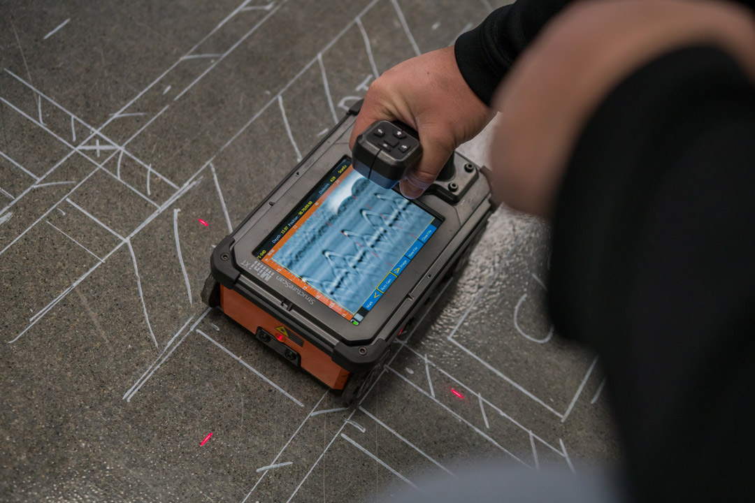
Concrete Imaging
While ground penetrating radar is the most common tool used to clear project areas before concrete saw cutting or core drilling, the GPR scanning equipment used by GPRS goes above and beyond the typical service provided. Our software provides each customer with much more detail such as key slab information including: rebar and post-tension spacing and depth, concrete cover and overlay thickness, concrete thickness, and even dowel placement.
GPRS’ ability to completely scan concrete structures in full is not limited by size. Therefore, comprehensive structural analysis can be performed on any site, be it commercial, residential, or industrial, and over any concrete surface such as slabs, walls, columns, and beams.
Once the scanning process is completed, a clear and accurate layout can be created of the vertical and horizontal position of any existing impediments such as post tension cables, rebar, beams, and conduit.
By scanning concrete structures prior to initiating the construction phase, costly change orders are greatly reduced and the redesign process is minimized. Most importantly, you can virtually eliminate dangerous and costly utility strikes. Unlike concrete x-ray approaches, our scanning technologies are able to comprehensively evaluate large areas and provide accurate modeling of all findings in detailed field sketches, CAD drawings, and/or 3D models with no risk to your workers.
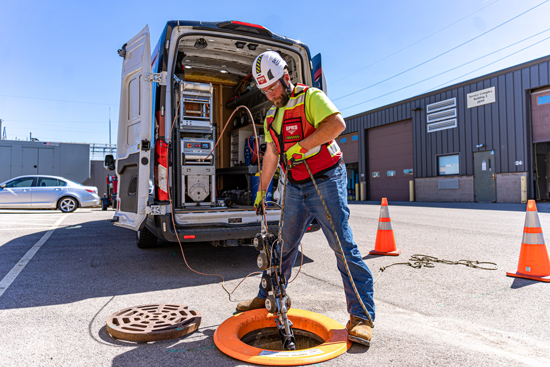
Video Pipe Inspections
Video Pipe Investigation (VPI) utilizes industry-leading CCTV cameras to perform sewer pipe inspection services. This NASSCO certified inspection process identifies faults and pipe defects by evaluating underground water, sewer lines, and lateral pipelines.
Our extensive services include cross bore prevention and mitigation, sewer and water inspections, lateral inspections, and manhole inspections. These services utilize modern surveying technology such as Robotic Crawlers (CCTV), Push Cameras, and Lateral Launch cameras to collect, map, and provide a complete NASSCO VPI report mapping each pipe defect, its severity, and video from within the pipe. This in-depth reporting allows you to greatly limit potholing, and to only excavate at the exact location that needs repair
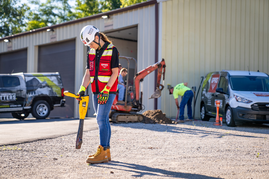
- Utility Locating
Whether you’re excavating, drilling, and/or boring, our GPRS Utility Locating Services are necessary for any infrastructure repair and maintenance project. Prior to breaking any ground, our fully comprehensive utility location methodologies provide the most accurate, data-driven representation of actual site conditions.
This process accounts for any unexpected variations, renovations, and unknown or abandoned pipes by utilizing non-destructive, ground penetrating radar (GPR) and EM (electromagnetic) locators, among other equipment, to scan the subsurface of any given site for utilities. Through this important process, projects can avoid unexpected, costly surprises that can arise when projects begin to break ground. These services can map and model the precise location of numerous underground utilities including water lines, gas lines, sanitary sewers, electric lines, and more to virtually eliminate utility strikes.
Each of these services are crucial evaluations to ensure the success of any project and should not be overlooked. By collecting accurate data from these processes, the exact locations of all potential hazards and how they spatially relate to each other can be accurately mapped and modeled so facility managers can plan for the entire project life cycle, including safety measures and estimated timelines. Through prioritizing these assessments, you and your team can better protect site employees from potential line strike damage, while also avoiding any unnecessary cost overruns, change orders, and/or redesigns.
Moreover, with our modern SiteMap® digital planning tools, construction teams are able to maintain detailed, up-to-date, accurate facility maps and models of all underground utilities located on the job site. This kind of information is key to sustaining proper communication on any construction project.
We are always striving to help our clients Visualize The Built World™ by providing high-resolution and accurate maps and models of any site. Learn more about how SiteMap® can help you completely visualize your facility in a new, innovative way by downloading our brochure and contacting us for a quote today!