FINCH Brands, a premier consumer insights firm, recently performed a large-scale survey of qualified facility management respondents within the construction industry. These 110 respondents, who were vetted for their level of experience and management responsibilities, are responsible for making capital expenditure decisions for their facilities and managing one or more building projects across multiple sites.
The goal of this study was to identify the major pain points for facility managers today, and the modern solutions needed to solve them. One of the tools demonstrated to the surveyed group was SiteMap®, powered by GPRS. SiteMap is a singular subsurface infrastructure mapping solution which allows facility managers and their teams to store, map, model, and share their facility data with ease. This industry-leading platform provides facility managers with the digital tools they need to succeed in construction projects of any size or complexity. SiteMap’s unparalleled visualization capabilities provide the solutions highlighted in The Finch Rerport’s most recent findings.
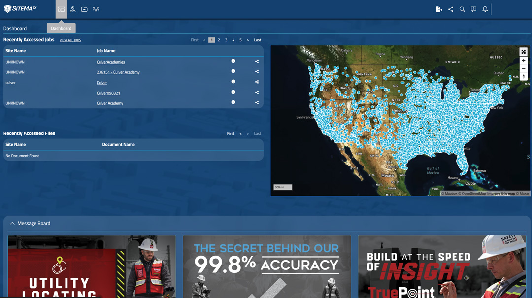
SiteMap’s services provide the best possible solutions, going above and beyond that of any standard GIS or cloud-based platform. With SiteMap®, facility managers and their teams are able to streamline communication, organization, and safety on any project, allowing for better collaboration than ever before. With this in mind, it’s no surprise that 90% of the facility managers surveyed who were not currently using a cloud-based system for data storage expressed interest in utilizing SiteMap® for their future projects. When asked more specifically which features of the platform appealed most to them, the following statistics were collected…
- 60% facility managers surveyed noted the 3D digital spatial information, i.e., mapping and modeling as a major benefit to SiteMap’s capabilities
- 55% participants expressed interest in using the underground utility & pipe inspection capabilities offered through GPRS and mapped/modeled via SiteMap
- A secondary benefit identified through the survey was SiteMap’s comprehensive access, as all the data needed for a project would now be in one place
- Another secondary benefit is the accuracy of information and models, with the most up-to-date information and real-time data being made available to all team members at once.
However, there are understandably lingering questions and concerns surrounding such a new platform. As reported by FINCH, a majority of these inquiries center around the functionality of the product, convenience of use, and necessary maintenance. We at SiteMap® are here to help address these questions and ease any concerns you or your team might still have!
Top 3 Frequently Asked SiteMap® Software Questions…
- How is the security of my data maintained in SiteMap, and how is it recovered if deleted?
Within the SiteMap® system, every locate and scan uploaded to our system is automatically backed up. In addition, if utilizing our GPRS mapping and modeling solutions, the full Job Services Report, which would at one time be sent as a collection of files team members would have to download separately, is now made available through SiteMap’s collaborative platform. This way, the most up-to-date and accurate documents for your project are properly maintained.
- How accurate is this system, is data updated in real time?
There is a continuous ingestion of data into SiteMap. Within five minutes of a Project Manager uploading the file, it will be displayed within SiteMap. As for the accuracy of the visualization rendered in the system, it is important to recognize that these results are only as accurate as the as-builts they’re referencing. If, for instance, these as-builts are obtained via our state-of-the-art GPRS services, then you can be assured all 3D laser scanning data (even raw point cloud files) is accurate within millimeters, any video pipe inspection data is NASSCO certified, and any concrete imaging or utility locating data collected is backed by our 99.8% success rate.
- Does the system require upkeep, or does it auto-update to avoid glitches?
No upkeep is involved when you are accessing SiteMap our website. The site will automatically update whenever necessary. Through these continuous auto-updates, the SiteMap team is responsible for taking the burden off the user and providing excellent online customer service and tutorials within our dashboard feature to help you better navigate the system. Stay tuned for more information about the mobile app coming soon!
Want to learn more about how you and your team can collaborate better using SiteMap®? Download our brochure, and contact us for a quote today!